
 |
| Fort Rosecrans National Cemetery, San Diego, California. August 31, 2014. Greg Gillson. |
In her web site to birding San Diego County (last updated about 2008?), Mary Beth Stowe gave brief directions to birding here, but I wasn't sure where to even park the car. Somehow, the directions were unclear. The first thing I had to do was reorient myself--the peninsula runs from the north almost straight south (not west, as I was trying to make it in my mind). Once that transition was made, compass directions made sense.
I received several replies to my request to the email list--some offering to show me around, others giving me directions and tips, including 3 maps. From these I made a huge map (below). Thank you, especially, to Annie Stockley, Nancy Christensen, Sara Mayers, Jennifer Baldwin, Susan Smith, and Geoff Rogers.

Getting there: From Hwy 8: Take it west until it ends into Sunset Cliff Blvd, then continue on to Nimitz Blvd. In 1/2 mile take the Famosa Blvd exit and follow the signs to Catalina Blvd/Fort Rosecrans National Cemetery/Cabrillo National Monument. From San Diego Airport: Take N Harbor Dr to Nimitz Blvd, turn left on Chatsworth until it ends at Catalina Blvd. Take Catalina left to the Cemetery. Parking: No charge. Most birders park on the east side of Cabrillo Memorial Drive in a dirt lot just outside the main entrance (see map below) and walk into the cemetery grounds. Some birders also drive into the cemetery proper (see "other notes" below). Hours: The Cemetery seems to be open at least dawn to dusk now. In the past the Cemetery grounds did not open on weekends until 9:00 AM, but was open much earlier on weekdays. Map Navigation: 1800 Cabrillo Memorial Drive, San Diego, CA 92106.
Where to bird: The main birding locations are noted on the map below. The ficus trees on the Northeast Loop and the pines along "The Dip" west of Cabrillo Memorial Drive are two popular locations to find rare birds. Birders move from tree to tree, examining each one. Many birds are also found along the perimeter fence line. Though probably best at dawn, a recent birder found different rare birds from dawn to late afternoon, apparently on several visits during the same day.
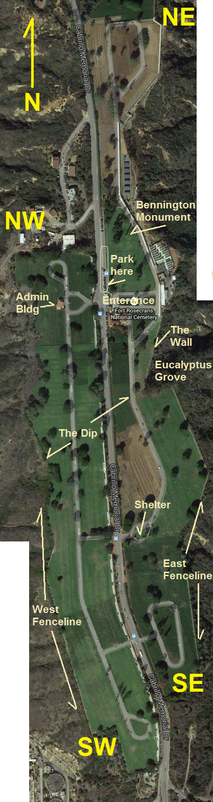
Other notes about birding this cemetery: Apparently there are no interments
So using this map I can now figure out where all this week's rare birds were!
9/1/2014:
Swainson's Thrush at The Wall9/3/2014:
Rose-breasted Grosbeak outside perimeter fence in far NE corner
Northern Waterthrush in the ficus trees in NE
American Redstart in the ficus trees in NE
Prairie Warbler in SE
Tennessee Warbler in ficus in NE loop9/4/2014:
American Redstart (continuing) same ficus tree in NE
Prairie Warbler (moved) Torrey Pine north of The Dip on the west side of Cabrillo
Olive-sided Flycatcher fence at the top of the hill north of The Dip
Brewer's Sparrow on west side along N Fence under pines
Prairie Warbler (continuing) same area north of The Dip on west side9/8/2014:
Green-tailed Towhee (#1) west of NW loop9/10/2014:
Green-tailed Towhee (#2) south of NE loop
Tennessee Warbler pines just north of The Dip on west side
Yellow-green Vireo in NE corner near Registrar of Graves
Grace's Warbler southeast of Admin Bldg(And yes, I misspelled "Entrance" on the map. I had "Enter" and then changed it.)
Thanks for this info. In Ebird, it is mentioned that No Birding between 8am-5pm. Is that currently enforced ?
ReplyDeleteI have heard from birders that the cemetery management does in fact want us out of there from 8-5, so I would respect the time limit so they don't say "no birding at all". I believe walking alongside the road by the cemetery is ok, and you can still see many birds there.
Delete