In the past 40 years I have been out to sea looking for birds about 200 times--150 of those on organized tours I set up and ran myself from Oregon for 20 years. The tour on May 16th was run by the
Buena Vista Audubon Society and I served as one of the guides. My assigned duty was keeping the official eBird list in the pelagic protocol. We ended up with 18 lists from each separate trip segment. Each checklist is a different area, direction, or hour-long segment. Links to each trip segment are included in the narrative below.
I'm still excited to join these pelagic birding trips. Having attended so many trips, though, it's hard for me to remember the excitement of my very first trip. Thus, I recommend also reading an account of this very same trip by a first-timer. Tommy DeBardeleben shares his excitement and
mal de mer worries (
The Big Year movie clip: "
pitching and tossing") on his "Tommy D's Birding Expeditions" blog with the post:
Deep Sea Birding -- The Grande Way.
 |
| The adventure begins! Birders aboard Grande in the Point Loma marina at dawn. |
The boat left the marina about 6:00 a.m. and made its way out of the bay, leaders calling out the numerous water birds as they flew or swam by. A large flock of Western Gulls and Brown Pelicans accompanied us, enticed by the popcorn chum we threw out.
[eBird checklist for
the marina]
[eBird checklist for
lower San Diego Bay]
We passed close by Ballast Point and spotted the frequently-present Black Oystercatcher on the cobble beach. Then we headed out into the ocean toward the "whistle buoy" that often serves as a
perch for Brown Boobies. But none were here today. Not to worry, we saw several throughout the day.
[eBird checklist for
mouth of San Diego Bay]
The mouth of San Diego Bay faces due south. So our course continued SSW about 6 miles until we neared the Mexican border. We followed the border westward another few miles, finding a couple nearshore-loving Black-vented Shearwaters. In this area we also picked up our first Pink-footed Shearwaters and Scripps's Murrelets--birds that we would see occasionally throughout the day.
[eBird checklist
southwest from the whistle buoy]
[eBird checklist
following the border west]
 |
| Pink-footed Shearwater over Nine Mile Bank. |
When we reached the south end of the Nine Mile Bank (an underwater
mountain range) we followed it north about 5 miles, which took a bit more than half-an-hour to travel.
[eBird checklist
WNW on Nine Mile Bank]
We dropped off into deeper water on the seaward side of the Nine Mile Bank and proceeded NW about 15 miles across a deeper plain known as the San Diego Trough.
[eBird checklist
San Diego Trough]
 |
| Scripps's Murrelet with chick over the San Diego Trough. |
Bird numbers were rather scarce during the hour-long trek over the San Diego Trough. We did see quite a few Sooty Shearwaters, and Black Storm-Petrels flitted about, and we saw more Scripps's Murrelets and a few distant fly-away Cassin's Auklets.
After an hour we started up the shallower slope of the underwater mountain range known as the Thirty Mile Bank. There were more Black Storm-Petrels here, and a few of the guides spotted a couple of Ashy Storm-Petrels, too. The rapid shallow wing strokes and direct but twisty flight was noticeably different from the leisurely deep wing strokes and long wings of the Black Storm-Petrels, whose flight reminds me of Black Terns. Against the strong harsh sunlight, all the storm-petrels looked quite blackish, so flight style was a much more reliable way to identify these birds (and, indeed, the alcids and shearwaters, too).
[eBird checklist
onto Thirty Mile Bank]
 |
| Black Storm-Petrel as we neared the Thirty Mile Bank. |
 |
| Sooty Shearwater as we neared the Thirty Mile Bank. |
 |
| Sooty Shearwater as we neared the Thirty Mile Bank. |
We then turned and followed the ridge line of Thirty Mile Bank northward.
[eBird checklist
north on Thirty Mile Bank]
 |
| Black Storm-Petrel over the Thirty Mile Bank. |
 |
| Elegant Tern over the Thirty Mile Bank. |
And we kept heading north until we eventually reached a point on Thirty Mile Bank where we were half way between Point Loma and the island of San Clemente--the imaginary line between San Diego County and Los Angeles County (San Clemente Island is part of Los Angeles County). There are often rafts of storm-petrels in this area, but none were found. This was the end point of our trip. We turned around and headed back into San Diego County waters again and toward the Nine Mile Bank.
[eBird checklist northern portion of
San Diego County on Thirty Mile Bank]
[eBird checklist
Los Angeles County on Thirty Mile Bank]
While heading back east across the San Diego Trough, we found a trio of Brown Boobies, and then another singleton.
[eBird checklist from Thirty Mile Bank
east across the San Diego Trough]
 |
| Brown Booby over the San Diego Trough. |
 |
| Brown Booby over the San Diego Trough. |
It was another hour and a half across the San Diego Trough heading toward shore. We reached the "182 spot." This is the shallowest point on the north end of the Nine Mile Bank--182 fathoms x 6 feet = 1092 feet deep. We didn't stay long, though; there just weren't any birds here.
[eBird checklist another hour east
across the San Diego Trough]
[eBird checklist chumming at
182 Spot]
It was 4:00 p.m. We'd been out 10 hours and our trip was nearly over. We were due back in port in just a little over 2 hours. And nothing of note had really been seen.
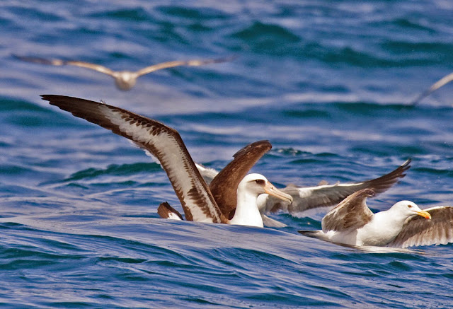
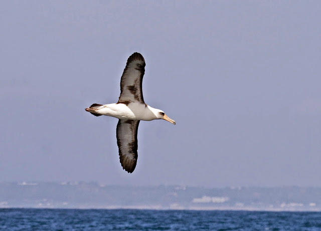
So we continued southeast on Nine Mile Bank. Two minutes later "Black-footed Albatross!" was called out on
Grande's public address system. And as everyone was still excitedly scrambling to get good looks as it circled the boat a couple of times, another announcement screamed out on the PA: "Laysan Albatross!" -- a
very rare bird indeed!
 |
| Black-footed Albatross with Western Gulls over Nine Mile Bank. |
 |
| Laysan Albatross over Nine Mile Bank. |
Soon thereafter, I spied a second Black-footed Albatross at the horizon over a mile a way, winging toward the boat, low over the water. It took a few minutes to come, and eventually everyone was on it. It flew right up to the boat and joined the gulls feeding on popcorn.
[eBird checklist Nine Mile Bank
Laysan Albatross location]
We spent about a half an hour stopped with the albatrosses around the boat. then we had to hurry back to port. We motored east. The albatrosses followed, falling back to inspect something, disappearing, then appearing minutes later to circle the boat and head away again.
[eBird checklist East
from Nine Mile Bank toward shore]
I had noted a couple of Common Terns flying over a few times during our trip, but views were distant and brief. Finally we got close views of two sitting on floating seaweed.
 |
| Common Terns between Nine Mile Bank and Point Loma. |
[eBird checklist
within 3 miles of shore]
[eBird checklist
back in the bay]
Trip Highlights
Greater White-fronted Goose 1 (harbor fly-over p.m.)
Laysan Albatross 1 (4th live county record?)
Black-footed Albatross 2
Black Storm-Petrel 84
Ashy Storm-Petrel 7
Brown Booby 10
Black Oystercatcher 1 (Ballast Point)
Royal Tern 6
Least Tern 24
Black Tern 2
Scripps's Murrelet 11
Cassin's Auklet 22
Rhinoceros Auklet 2
Map track of our route provided by Dave Povey.


