Showing posts with label eBird tips. Show all posts

Tuesday, April 3, 2018

A dozen Sage Thrashers! Desert Avicaching

I scored two points!

While birding in Borrego Springs recently, I remembered that I had previously entered some locations on my maps application to search for desert thrashers this spring for something called "Avicaching." Of course, I had forgotten most of the details. But I knew that birding surveys usually happen at dawn. So we were too late in the day to make an "official" survey. But why not check out the location in case we get another opportunity this spring? So Marlene and I headed south from Borrego Springs after lunch. We stopped at Yaqui Well where I walked in and found the two Long-eared Owls (no photos) that have been present this winter. Then we continued on to Scissors Crossing and headed south about 12 miles to Blair Valley.

We easily found the survey sites on two miles of sandy dirt roads that were no problem for our Kia Soul--two wheel drive but about 10 inches of clearance. We didn't have much time, so we only visited two of the three survey sites for less than a half hour each.

What is Avicaching? The details for this Desert Avicaching survey is here. Basically, this is eBird + Geocaching. Survey sites in under-birded areas or habitats are set up as eBird Hotspots. Record birds here during the survey period (February 1 to June 15, 2018). Surveys should be 20-60 minutes and travel less than 1 mile to be valid.

Even though I wasn't there before 10:00 am, I noted that my eBird list was automatically entered into the Desert Avicaching Leaderboard. I scored two points!

Sage Thrasher
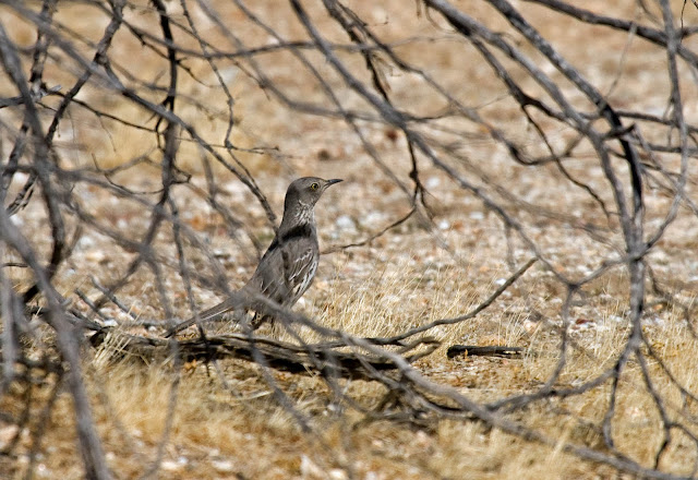
Sage Thrasher. Blair Valley, California. March 18, 2018.
Avicaching is fun! This particular project contributes to knowledge of birds in remote desert areas that may be impacted by solar farms. In this case, Sage Thrashers migrate through this area in large numbers. And who knows, perhaps Le Conte's Thrashers may be resident here. Further north, in San Bernardino County, breeding Bendire's Thrashers may be impacted. Other Avicaching points continue in the Mojave Desert to Death Valley and Las Vegas, Nevada.

Birdless. That's the first impression one has of Blair Valley survey points. The low spot on the valley is a dry lake bed. Last year spring rains brought a "Super-Bloom" to the desert. Very little moisture this winter, so just year-old dry grass in the lake bottom. At the edges, sparse well-spaced creosote bushes begin. Then some Gander's cholla and Mojave yucca (like smaller Joshua trees). That's the vegetation of one of the survey sites.

Sage Thrasher

But scanning across the creosote I spy several solitary robin-like birds hopping on the ground--Sage Thrashers! And they are more common than one would think. After I entered 2 birds on the checklist the rarity flag in eBird popped up. I quickly reached 9 birds, and finally 12 birds after walking a couple hundred feet out and then returned to the car in a large loop around the survey point. That surpasses the total number of Sage Thrashers I've seen total in the Anza-Borrego desert the past 3 years!

Sage Thrasher

Driving out past the camping area there were several Mourning Doves, a Verdin called, and several Black-throated Sparrows flitted about. There were certainly birds here, especially up next to the rocky hill, but it requires work to find them.

Sage Thrasher

The second survey point was closer to the highway. There was more vegetation here. Some gravelly areas included cholla, barrel and hedgehog cacti, California juniper, and desert agave. As the gravel gave way to sand, it was again creosote, cholla, and Mojave yucca.

Blair Valley

The gravel/cactus area seemed good for Black-throated Sparrows. But none revealed themselves. I walked a couple hundred feet without encountering any sign of any birds. I was really thinking I was going to submit a 20-minute checklist with no birds recorded! Then I heard a very distant raven. Looping around back to the car I heard the chugging of a far-off Cactus Wren. When I reached the car I heard the caroling melody of a singing Sage Thrasher back where I had been. Three species, three total individuals, none seen. Then two ravens flew up right over me!

First eBird checklist.

Second eBird checklist.

Even though birds were sparse, I enjoyed visiting a new area for me and contributing to the knowledge of birds in a very under-birded location. I hope to get out there again a time or two this spring. I would really enjoy it if there were more avicaching projects to participate in. Perhaps it could be done as a follow-up to the bird atlas project that was done about 20 years ago in San Diego County. I know I really enjoyed the Oregon Breeding Bird Atlas project done about the same time. Fun!

Saturday, August 26, 2017

eBird Tracks: What is it? What can it be?

eBird has added a new feature to their eBird mobile app. At this time it is only in Android, but they are working on an iOS version. I am really excited about the potential for this feature, called Tracks.

What is it?
eBird Tracks is a feature of the mobile app that creates a map with a track of your birding movements for each traveling checklist you make.


Screenshot: eBird Tracks of a recent birding hike I took on the Weir Trail at Palomar Mountain State Park.
What are the benefits now?
As stated, it came first on Android devices. So right now Tracks is only available on that platform. And right now the map track is only visible on the phone that created the checklist when you review that checklist. Not too exciting. The only benefit you get now is seeing on a map where you birded and having a very accurate measurement of how far your traveled.

What are the future uses for eBird Tracks?
This is really exciting for me to think about. Those tracks that only I can see now on my phone? They are captured in eBird and will be available for others in the future. Have you ever looked at the map for a rare sighting and found the Hotspot was a large area and you didn't know where in it the bird was? Well, with Tracks you'll at least have a map with the birding track on it. So you will know where to begin and what route to take.

When you visit the Hotspots section of eBird, you should be able to view the routes of recent birders to that location. This will give you a good idea of the route other birders regularly take, and maybe help you discover a new trail.

I also think that the eBird team should consider adding a feature to tag a specific bird's location. This function was available in the predecessor, BirdLog, and I've missed it for tagging exact locations in the comments section for certain birds.

The official announcement of eBird Tracks is here.

Tuesday, October 18, 2016

eBird Profile Pages

For the past few weeks I have been adding bird photos to my older eBird checklists.

In July I wrote about the new eBird Media Search tool. That allows one to search for photos and audio records that have been added to eBird checklists. It has only been since November 2015 that you could add photos to your checklists. Now, however, a new feature, called Profile Pages has been added to eBird. If a person so chooses, he can add a blurb about himself and make it publicly viewable. It shows a map with the number of species recorded in each country, state, county, along with the bird photos from each.

I knew I have over 325 photos of birds from Oregon, and must be over 200 in San Diego County now. But the eBird Profile pages says I had far fewer photos in my checklists. So I went back to 2002 and added photos to my checklists. I just completed adding all my bird photos to all checklists today. 536 species recorded in the United States, 411 of those photographed. 417 species recorded in Oregon, 336 of those photographed. 334 species recorded in San Diego County, California, 280 of those photographed. Here is my profile page.

eBird profile page
My eBird Profile page. From here one can zoom in or out to different world, country, state, or county levels.
Besides the different geopolitical levels you can zoom to, you may also view all their photos that have been added to eBird checklists. IF (a big if, but highly recommended) the photographer has ranked the quality of their photos then you can sort on their best photos, along with newest and oldest. And those choices are also sortable with the zoom to each geopolitical level.

This is a good tool for tracking your own photos and species seen, and also view the same for others.

So how do you find out who has a profile you can view? The best way is to Explore Data, Top 100, and choose the state and county where they bird they most. If they have a public profile page their name will be highlighted as a web link. Click and view!

Like this:


This feature is just getting started. I suspect (hope) that additional tools will be added to the Profile pages. One thing I want is my checklist to note whether I have ever photographed a species or not. That way I can go out and take photos of birds I've never obtained in whatever region I am interested in.

Play around in the Profile page and you can see that the maps change by clicking on "Species Observed" and "Species w/ Photos." Fun stuff!

Thursday, July 7, 2016

New eBird Media Search

Last November eBird allowed photos, video, and audio to be uploaded with your eBird checklists and stored on the Macaulay Library archive. So, when you take a photo and add it to your checklist you add to the scientific collection. By May of this year over a half million bird photos have been uploaded. Numerous video and audio files have been stored, too.

And now you can search these photos!

Each photo becomes what they call a "digital specimen." What does that mean? Well, it allows scientists and anyone interested to view rare bird records, for instance, and actually see the bird. In the not-so-distant past, rare birds had to be shot, killed, skinned, and sent to museums where the specimen was kept forever as verifiable physical evidence supporting an identification. These archived photos kept at the Macaulay Library of the Cornell Lab of Ornithology now do the same things with digital evidence, and no birds were killed!

But it doesn't have to be a rare bird, such as a first state record, or something like that. It can be a common bird. Did you get a really great photo of a bird common to your area? Add it to your eBird checklist. Birds vary across their range--they may not all look exactly alike everywhere they occur. Your photo could be used to find heretofore unknown variation. Even more exciting, such variation may even reveal cryptic, or "hidden," species--a new species hiding among some common bird that we didn't even know existed. These cryptic species are not just found in some far-way, never-birded, jungle somewhere. New species are being described from well-birded areas all the time--birds that look alike but don't breed with each other when they meet because of song or courtship differences (take for example the recent splitting of a former single species of small little brown Holarctic wren into three species: the European Wren, Winter Wren, and Pacific Wren). Your photos could be valuable for discovering some of these. And even if not, just having your bird photos put in a digital museum is kind of neat, isn't it? You can be the local collector for a notable museum! How cool is that?!!! ("Cool" and "neat"? Yes a child of the 60's.)

Here is a recent checklist with photos that I submitted. ("Yes, I'm a local collector for the museum at the Cornell Laboratory of Ornithology." Ooh, I like it!)

So, besides storing your own bird photos with your checklists, what do you do with this new feature?

Well, here's a link that takes you to the most recent photos of San Diego County birds. Change the filter to search your own county or state,... or somewhere else, even far away.

How do I use this? I check out the new photos added recently from my area. ("Oh, the rare bird that's being seen nearby is a dull first-year bird and not the full adult male as in the field guide?") That helps me form a search image when I go look for the reported rarity... or just keep my eyes open for finding my own rarity in my own patch. Or, perhaps you note the unique habitat ("Oh, it's on the ground in the cattail marsh. And here I was looking for it in the tops of the spruce trees."). There's no limit of what you might learn just by looking at recent photos of birds in your own area.

I expect to discover even more uses for the photos, video, and audio in this digital museum. What will you use them for?

Friday, April 15, 2016

A secret eBird function: most-recently seen

&rank=mrec
&rank=lrec

I've been after the eBird development crew for a few years to add an option to sort lists by the most-recently seen, in addition to the first-time seen (Life Bird).

The way it is now, if you create your life list and then sort by date, the first bird on your list will be your very first bird ever recorded for eBird. In my case, it is a Red-breasted Sapsucker seen in Oregon in 1972.

I've seen lots of Red-breasted Sapsuckers since that first one. The question I really want to ask now is, "What is the bird that I haven't seen in the longest time?" In my case, as far as eBird records go, it is a Black-billed Cuckoo on my grandfather's farm in Minnesota in June 1977. In all my 40 years since then, I have never seen another Black-billed Cuckoo.

Why would you want this feature? Well, if you were doing a County Big Year you might want to know which species you haven't seen in years, and concentrate on finding those. Even if you are not into Big Years or listing, per se, wouldn't it be nice to have eBird make you a list of birds you haven't seen in a very long time? Then you could plan some trips to look for them--perhaps in an area or habitat you haven't visited in a while.

eBird Most Recent
A section of my "Most-recent" list of birds I've seen in Washington County, Oregon. These aren't the first time I saw these birds in the county, rather, the last time I saw them there!
It is true that many of the birds you haven't seen for a long time are likely to be rarer. But perhaps you'll find there are a few that are common enough that you just haven't seen in a while. It's time you became reacquainted!

Recently, I stumbled upon the answer when I was researching the Hotspots in eBird. One of the lists for birds in the Hotspots is most-recently-seen birds!

Ready? Here's how:

In eBird go to "My eBird"
Click on the link for number of birds you've seen in "My Life List"
Your life list now appears
In the web browser bar (the one beginning "ebird.org/ebird/MyEBird?cmd..." go to the end of the link and add the following characters with no spaces: "&rank=mrec"
Hit ENTER or click the reload page button to send the command.

There's your list of the very last time you've seen each species!

This works with any of your lists: Life, Country, State, County.

NOTE: when all done, do it again with "&rank=lrec" this time to bring it back to the default order, or your lists will be stuck with most-recent first.

Saturday, May 30, 2015

BirdLog to become FREE eBird Mobile

eBird is the indispensable tool of today's birders. Binoculars, field guide, eBird. There are some "that's not the way I watch birds" holdouts, but by and far, over the past 15 years or so, bird watching has come to be synonymous with eBird.

eBird logo

eBird is a free real-time online checklist program with powerful tools that let you keep track of your own bird lists. Its power comes from its ability to also see the range, frequency, and abundance of birds around the world as entered by tens of thousands of eBird users. On a recent "Global Big Day" on May 9, 2015 there were 13,664 eBird users that submitted 42,920 checklists that contained 6,013 different bird species. One. Single. Day.

For entering your eBird lists in the field, there is nothing better than the BirdLog smart phone app by Birds In the Hand, LLC. It first hit the market in March 2012. Frankly, it was the reason I purchased my first smart phone.

The Cornell Lab of Ornithology, the host of eBird, recognizes the great utility of BirdLog, calling it "critical to eBird." Thus, the Lab obtained the rights to BirdLog and will make some changes and offer it FREE as eBird Mobile.

eBird Mobile is now in beta testing for iOS phones and will likely be available for Android phones soon. Since I have an Android phone I do not have a personal review for you of the beta version. In fact, I cannot find a review online... yet.

Keep watching!

See older posts of mine about eBird and BirdLog on the now-idle "Pacific NW Birder" blog:

"What is eBird?" November 15, 2010

"BirdLog 'Killer App' for eBirders" March 19, 2012

"eBird Best Practices: Using Birdlog" July 26, 2013

Wednesday, December 17, 2014

eBird: Target Species

I don't know when it appeared, but a new function on eBird, "Target Species," has some really exciting applications.

If you don't know about eBird, I wrote 20 posts about eBird, and how to get the most out of it, from 2010-2012 on my (now inactive) Pacific NW Birder blog. Suffice it to say, I said, without hyperbole: "eBird is an absolutely indispensable real time world-wide bird status and distribution tool."

I've been living in San Diego County, now, for just over a year. Here's a question I want to know: What species that I haven't seen yet are the easiest to find in the county? Even more practical: What birds that I haven't seen yet in the county are the most likely for me to find next month?

Those questions are answered with the Target Species function in eBird. What did I learn?

The top 5 reported birds in the county, for the entire year, that I haven't seen yet are these:
1. Snowy Plover
2. Lawrence's Goldfinch
3. Red-crowned Parrot
4. Hermit Warbler
5. Canyon Wren

Well, it's winter now, so I'm not going to see some of these birds as easily now as later in the year. So, how about I use this eBird function to plan birding trips next month to look for some of these "easy" ones? What are the top 5 reported birds in January that I have yet to see in San Diego County?

1. Snowy Plover
2. Reddish Egret
3. Green-tailed Towhee
4. Red-crowned Parrot
5. Virginia Rail

Now, I have a reasonable list of target birds to look for in the next month or so. I can use eBird Needs Alert and the San Diego Region Birding email list to learn of recent reports of these birds. I can also use the eBird map function to map all previous reports and look at only winter.